




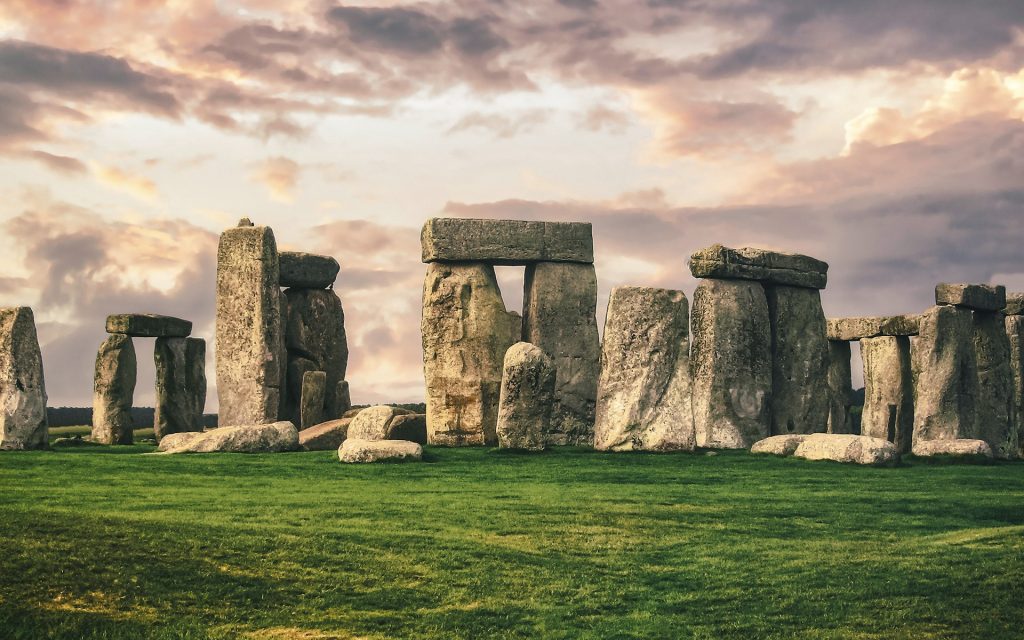
Stonehenge is a prehistoric megalithic structure on Salisbury Plain in Wiltshire, England, two miles (3 km) west of Amesbury. It consists of an outer ring of vertical sarsen standing stones, each around 13 feet (4.0 m) high, seven feet (2.1 m) wide, and weighing around 25 tons, topped by connecting horizontal lintel stones which are held in place with mortise and tenon joints—a feature unique among contemporary monuments. Inside is a ring of smaller bluestones. Inside these are free-standing trilithons: two bulkier vertical sarsens joined by a single lintel. The whole monument, now in ruins, is aligned towards the sunrise on the summer solstice and sunset on the winter solstice. The stones are set within earthworks in the middle of the densest complex of Neolithic and Bronze Age monuments in England, including several hundred tumuli (burial mounds).
Stonehenge was constructed in several phases, beginning about 3100 BC and continuing until about 1600 BC. The famous circle of large sarsen stones was placed between 2600 BC and 2400 BC. The surrounding circular earth bank and ditch, which constitute the earliest phase of the monument, have been dated to about 3100 BC. Radiocarbon dating suggests that the bluestones were given their current positions between 2400 and 2200 BC, although they may have been at the site as early as 3000 BC.
One of the most famous landmarks in the United Kingdom, Stonehenge is regarded as a British cultural icon. It has been a legally protected scheduled monument since the Ancient Monuments Protection Act 1882 was passed. The site and its surroundings were added to UNESCO's list of World Heritage Sites in 1986. Stonehenge is owned by the Crown Estate and managed by English Heritage; the surrounding land is owned by the National Trust.
Stonehenge could have been a burial ground from its earliest beginnings. Deposits containing human bone date from as early as 3000 BC, when the ditch and bank were first dug, and continued for at least another 500 years.
Contents
Etymology
The Oxford English Dictionary cites Ælfric's 10th-century glossary, in which henge-cliff is given the meaning 'precipice', or stone; thus, the stanenges or Stanheng "not far from Salisbury" recorded by 11th-century writers are "stones supported in the air". In 1740, William Stukeley notes: "Pendulous rocks are now called henges in Yorkshire ... I doubt not, Stonehenge in Saxon signifies the hanging stones." Christopher Chippindale's Stonehenge Complete gives the derivation of the name Stonehenge as coming from the Old English words stān 'stone', and either hencg 'hinge' (because the stone lintels hinge on the upright stones) or hen(c)en 'to hang' or 'gallows' or 'instrument of torture' (though elsewhere in his book, Chippindale cites the 'suspended stones' etymology).
The "henge" portion has given its name to a class of monuments known as henges. Archaeologists define henges as earthworks consisting of a circular banked enclosure with an internal ditch. As often happens in archaeological terminology, this is a holdover from antiquarian use.
Early history
Mike Parker Pearson, leader of the Stonehenge Riverside Project based around Durrington Walls, noted that Stonehenge appears to have been associated with burial from the earliest period of its existence:
Stonehenge was a place of burial from its beginning to its zenith in the mid third [sic] millennium B.C. The cremation burial dating to Stonehenge's sarsen stones phase is probably just one of many from this later period of the monument's use and demonstrates that it was still very much a domain of the dead.
Stonehenge evolved in several construction phases spanning at least 1500 years. There is evidence of large-scale construction on and around the monument, perhaps extending the landscape's time frame to 6500 years. Dating and understanding the various phases of activity are complicated by disturbance of the natural chalk by periglacial effects and animal burrowing, poor quality early excavation records, and a lack of accurate, scientifically verified dates. The modern phasing most generally agreed to by archaeologists is detailed below. Features mentioned in the text are numbered and shown on the plan, right.
Before the monument (from 8000 BC)
Archaeologists have found four, or possibly five, large Mesolithic postholes (one may have been a natural tree throw), which date to around 8000 BC, beneath the site of the tourist car park that was in use until 2013. These held pine posts around two feet six inches (0.75 m) in diameter, which were erected and eventually rotted in place. Three of the posts (and possibly four) were aligned east–west, which may have had ritual significance. Another Mesolithic astronomical site in Britain is Warren Field in Aberdeenshire, which is considered the world's oldest lunisolar calendar, corrected yearly by observing the midwinter solstice. Similar but later sites have been found in Scandinavia. A settlement that may have been contemporaneous with the posts has been found at Blick Mead, a reliable year-round spring one mile (1.6 km) from Stonehenge.
Salisbury Plain was still wooded, but 4,000 years later, during the earlier Neolithic, people built a causewayed enclosure at Robin Hood's Ball and long barrow tombs in the surrounding landscape. In approximately 3500 BC, a Stonehenge Cursus was built 2,300 feet (700 m) north of the site as the first farmers began clearing the trees and developing the area. Other previously overlooked stone or wooden structures and burial mounds may date as far back as 4000 BC; charcoal from the Blick Mead camp has been dated to that time. The University of Buckingham's Humanities Research Institute believes that the community who built Stonehenge lived there for several millennia, making it potentially "one of the pivotal places in the history of the Stonehenge landscape."
Stonehenge 1 (c. 3100 BC)
The first monument consisted of a circular bank and ditch enclosure made of Late Cretaceous (Santonian Age) Seaford chalk, measuring about 360 feet (110 m) in diameter, with a large entrance to the north east and a smaller one to the south. It stood in open grassland on a slightly sloping spot. The builders placed the bones of deer and oxen in the bottom of the ditch, as well as some worked flint tools. The bones were considerably older than the antler picks used to dig the ditch, and the people who buried them had looked after them for some time prior to burial. The ditch was continuous but had been dug in sections, like the ditches of the earlier causewayed enclosures in the area. The chalk dug from the ditch was piled up to form the bank. This first stage is dated to around 3100 BC, after which the ditch began to silt up naturally. Within the outer edge of the enclosed area is a circle of 56 pits, each about 3.3 feet (1 m) in diameter, known as the Aubrey holes after John Aubrey, the 17th-century antiquarian who was thought to have first identified them. These pits and the bank and ditch together are known as the Palisade or Gate Ditch. The pits may have contained standing timbers creating a timber circle, although there is no excavated evidence of them. A recent excavation has suggested that the Aubrey Holes may have originally been used to erect a bluestone circle. If this were the case, it would advance the earliest known stone structure at the monument by some 500 years.
In 2013, a team of archaeologists, led by Parker Pearson, excavated more than 50,000 cremated bone fragments, from 63 individuals, buried at Stonehenge. These remains were originally buried individually in the Aubrey holes, but were exhumed in 1920 during an excavation by William Hawley, who considered them unimportant and in 1935 re-buried them together in one hole, Aubrey Hole 7. Physical and chemical analysis of the remains has shown that the cremated were almost equally men and women, and included some children. There is evidence that the underlying chalk beneath the graves was crushed by substantial weight, so the team concluded that the first bluestones brought from Wales may have been used as grave markers. Radiocarbon dating of the remains has put the date of the site 500 years earlier than previously estimated, to around 3000 BC. A 2018 study of the strontium content of the bones found that many of the individuals buried there around the time of construction had probably come from near the source of the bluestone in Wales and had not extensively lived in the area of Stonehenge before death.
Between 2017 and 2021, studies by Parker Pearson and his team suggested that the bluestones used in Stonehenge had been moved there following dismantling of a stone circle of identical size to the first known Stonehenge circle (110 m (360 ft)) at the Welsh site of Waun Mawn in the Preseli Hills. It had contained bluestones, one of which showed evidence of having been reused in Stonehenge. The stone was identified by its unusual pentagonal shape and by luminescence soil dating from the filled-in sockets which showed the circle had been erected around 3400–3200 BC, and dismantled around 300–400 years later, consistent with the dates attributed to the creation of Stonehenge. The cessation of human activity in that area at the same time suggested migration as a reason, but it is believed that other stones may have come from other sources.
Stonehenge 2 (c. 2900 BC)
The second phase of construction occurred approximately between 2900 and 2600 BC. The number of postholes dating to the early third millennium BC suggests that some form of timber structure was built within the enclosure during this period. Further standing timbers were placed at the northeast entrance, and a parallel alignment of posts ran inwards from the southern entrance. The postholes are smaller than the Aubrey Holes, being only around 16 inches (0.4 m) in diameter, and are much less regularly spaced. The bank was purposely reduced in height, and the ditch continued to silt up.
At least twenty-five of the Aubrey Holes are known to have contained later, intrusive, cremation burials dating to the two centuries after the monument's inception. It seems that whatever the holes' original function was, it became a funerary one during Phase two. Thirty further cremations were placed in the enclosure's ditch and at other points within the monument, mostly in the eastern half. Stonehenge is therefore interpreted as functioning as an enclosed cremation cemetery at this time, the earliest known cremation cemetery in the British Isles. Fragments of unburnt human bone have also been found in the ditch-fill. Dating evidence is provided by the late Neolithic grooved ware pottery found in association with the features of this phase.
Stonehenge 3 I (c. 2600 BC)
Archaeological excavation has indicated that around 2600 BC, the builders abandoned timber in favour of stone and dug two concentric arrays of holes (the Q and R Holes) in the centre of the site. These stone sockets are only partly known (hence, on present evidence, are sometimes described as forming 'crescents'); however, they could be the remains of a double ring. Again, there is little firm dating evidence for this phase. The holes held up to 80 standing stones (shown blue on the plan), only 43 of which can be traced today. It is generally accepted that the bluestones (some of which are made of dolerite, an igneous rock), were transported by the builders from the Preseli Hills, 150 miles (240 km) away in modern-day Pembrokeshire in Wales. Another theory is that they were brought much nearer to the site as glacial erratics by the Irish Sea Glacier although there is no evidence of glacial deposition within southern central England. A 2019 publication announced that evidence of Megalithic quarrying had been found at quarries in Wales identified as a source of Stonehenge's bluestone, indicating that the bluestone was quarried by human agency and not transported by glacial action.
The long-distance human transport theory was bolstered in 2011 by the discovery of a megalithic bluestone quarry at Craig Rhos-y-felin, near Crymych in Pembrokeshire, which is the most probable source of some of the stones. Other standing stones may well have been small sarsens (sandstone), used later as lintels. The stones, which weighed about two tons, could have been moved by lifting and carrying them on rows of poles and rectangular frameworks of poles, as recorded in China, Japan, and India. It is not known whether the stones were taken directly from their quarries to Salisbury Plain or were the result of the removal of a venerated stone circle from Preseli to Salisbury Plain to "merge two sacred centres into one, to unify two politically separate regions, or to legitimise the ancestral identity of migrants moving from one region to another". Evidence of a 110-metre (360 ft) stone circle at Waun Mawn near Preseli, which could have contained some or all of the stones in Stonehenge, has been found, including a hole from a rock that matches the unusual cross-section of a Stonehenge bluestone "like a key in a lock". Each monolith measures around 6.6 feet (2 m) in height, between 3.3 and 4.9 ft (1 and 1.5 m) wide and around 2.6 feet (0.8 m) thick.
What was to become known as the Altar Stone was believed to have been derived from the Senni Beds, perhaps from 50 miles (80 kilometres) east of the Preseli Hills in the Brecon Beacons. Work announced in 2024 by a team from Curtin University, who analysed the chemical composition of fragments of rock that had fallen off the Altar Stone, and dated them, found that the best match was with rocks in the Orcadian Basin (which includes Caithness, Orkney, and the Moray Firth regions of north-eastern Scotland). The researchers stated that this implies the stone was transported some 430 miles (690 km), and thus demonstrates cultural links between Southern England and Northern Scotland.
Stonehenge 3 II (2600 BC to 2400 BC)
During the next major phase of activity, 30 enormous Oligocene–Miocene sarsen stones (shown grey on the plan) were brought to the site. They came from a quarry around 16 miles (26 km) north of Stonehenge, in West Woods, Wiltshire. The stones were dressed and fashioned with mortise and tenon joints before 30 sarsens were erected in a circle of standing stones approximately 98 feet (30 m) in diameter, with a ring of 30 lintel stones resting on top. The lintels were fitted to one another using tongue and groove joints – a woodworking method, again. Each standing stone was around 13.5 feet (4.11 m) high, 7.0 feet (2.13 m) wide, and 3.5 feet (1.06 m) deep, weighing around 26 tons. Each had clearly been worked with the final visual effect in mind: The orthostats widen slightly towards the top to keep their perspective constant when viewed from the ground, while the lintel stones curve slightly to continue the circular appearance of the earlier monument.
The inward-facing surfaces of the stones are smoother and more finely worked than the outer surfaces. The average thickness of the stones is 3.6 feet (1.1 m) and the average distance between them is 3.3 feet (1 m). A total of 75 stones would have been needed to complete the circle (60 stones) and the trilithon horseshoe (15 stones). It was thought the ring might have been left incomplete, but an exceptionally dry summer in 2013 revealed patches of parched grass which may correspond to the location of missing sarsens. The lintel stones are each around 10 feet (3.2 m) long, 3.3 feet (1 m) wide and 2.6 feet (0.8 m) thick. The tops of the lintels are 16 feet (4.9 m) above the ground.
Within this circle stood five trilithons of dressed sarsen stone arranged in a horseshoe shape 45 feet (13.7 m) across, with its open end facing northeast. These huge stones, ten uprights and five lintels, weigh up to 50 tons each. They were linked using complex jointing. They are arranged symmetrically. The smallest pair of trilithons were around 20 feet (6 m) tall, the next pair a little higher, and the largest, single trilithon in the south-west corner would have been 24 feet (7.3 m) tall. Only one upright from the Great Trilithon still stands, of which 22 feet (6.7 m) is visible, and a further 7.9 feet (2.4 m) is below ground. The images of a 'dagger' and 14 'axeheads' have been carved on stone 53, one of the sarsens; further axehead carvings have been seen on the outer faces of stones 3, 4, and 5. The carvings are difficult to date but are morphologically similar to late Bronze Age weapons. Early 21st-century laser scanning of the carvings supports this interpretation. The pair of trilithons in the north-east is the smallest, measuring around 20 feet (6 m) in height; the largest, which is in the south-west of the horseshoe, is almost 25 feet (7.5 m) tall.
Stonehenge 3 III (2400 BC to 2280 BC)
Later in the Bronze Age, although the exact details of activities during this period are still unclear, the bluestones appear to have been re-erected. They were placed within the outer sarsen circle and may have been trimmed in some way. Like the sarsens, a few have timber-working-style cuts, suggesting that during this phase they may have been linked to lintels and part of a larger structure.
Stonehenge 3 IV (2280 BC to 1930 BC)
This phase saw further rearrangement of the bluestones. They were arranged in a circle between the two rings of sarsens and in an oval at the centre of the inner ring. Some archaeologists argue that some of these bluestones were from a second group brought from Wales. All the stones formed well-spaced uprights without any of the linking lintels inferred in Stonehenge 3 III. The Altar Stone may have been moved within the oval at this time and re-erected vertically. Although this would seem the most impressive phase of work, Stonehenge 3 IV was rather shabbily built compared to its immediate predecessors, as the newly reinstalled bluestones were not well-founded and began to fall over. However, only minor changes were made after this phase.
Stonehenge 3 V (1930 BC to 1600 BC)
Soon afterwards, the northeastern section of the Phase 3 IV bluestone circle was removed, creating a horseshoe-shaped setting (the Bluestone Horseshoe) which mirrored the shape of the central sarsen Trilithons. This phase is contemporary with the Seahenge site in Norfolk.
After the monument (1600 BC on)
The Y and Z Holes are the last known construction at Stonehenge, built about 1600 BC, and the last usage of them was probably during the Iron Age. Roman coins and medieval artefacts have been found in or around the monument, but it is unknown whether it was in continuous use throughout British prehistory and beyond, or exactly how it would have been used. Notable is the massive Iron Age hillfort known as Vespasian's Camp (despite its name, not a Roman site), built alongside the Avenue near the Avon. A decapitated seventh-century Saxon man was excavated from Stonehenge in 1923. The site was known to scholars during the Middle Ages and since then it has been studied and adopted by numerous groups.
Function and construction
Stonehenge was produced by a culture that left no written records. Many aspects of Stonehenge, such as how it was built and for what purposes it was used, remain subject to debate. A number of myths surround the stones. The site, specifically the great trilithon, the encompassing horseshoe arrangement of the five central trilithons, the heel stone, and the embanked avenue, are aligned to the sunset of the winter solstice and the opposing sunrise of the summer solstice. A natural landform at the monument's location followed this line, and may have inspired its construction. It has been conjectured that the design of the monument included a celestial observatory function, which might allow prediction of eclipse, solstice, equinox and other celestial events important to the builders' belief system. The excavated remains of culled animal bones suggest that people may have gathered at the site for the winter rather than the summer.
There is little or no direct evidence revealing the construction techniques used by the Stonehenge builders. Over the years, various authors have suggested that supernatural or anachronistic methods were used, often asserting that the stones could not have been moved otherwise due to their massive size. However, conventional techniques, using Neolithic technology as basic as shear legs, have been demonstrably effective at moving and placing stones of a similar size. The most common theory of how prehistoric people moved megaliths has them creating a track of logs along which the large stones were rolled. Another megalith transport theory involves the use of a type of sleigh running on a track greased with animal fat. An experiment with a sleigh carrying a 40-ton slab of stone was successfully conducted near Stonehenge in 1995; a team of more than 100 workers managed to push and pull the slab along the 18-mile (29 km) journey from the Marlborough Downs.
Proposed functions for the site include usage as an astronomical observatory or as a religious site. In the 1960s, Gerald Hawkins described in detail how the site was apparently set out to observe the Sun and Moon over a recurring 56-year cycle. More recently, two major new theories have been proposed. Geoffrey Wainwright, president of the Society of Antiquaries of London, and Timothy Darvill, of Bournemouth University, have suggested that Stonehenge was a place of healing—the primeval equivalent of Lourdes. They argue that this accounts for the high number of burials in the area and for the evidence of trauma deformity in some of the graves. However, they do concede that the site was probably multifunctional and used for ancestor worship as well. Isotope analysis indicates that some of the buried individuals were from other regions. A teenage boy buried approximately 1550 BC was raised near the Mediterranean Sea; a metal worker from 2300 BC dubbed the "Amesbury Archer" grew up near the Alpine foothills of Germany; and the "Boscombe Bowmen" probably arrived from Wales or Brittany, France.
Stonehenge-builders and DNA studies
There is evidence to suggest that despite the introduction of farming in the British Isles, the practice of cereal cultivation fell out of favour between 3300 and 1500 BC, with much of the population following a pastoralist subsistence pattern focused on hazelnut gathering and pig and cattle rearing. A majority of Stonehenge's major phases of construction occurred during this period, during which evidence of large-scale agriculture is equivocal. Similar associations between non-cereal farming subsistence patterns and monumental construction are seen at Poverty Point and Sannai Maruyama.
Stonehenge I and II
Researchers studying DNA extracted from Neolithic human remains across Britain determined that the people who built Stonehenge I and II were closely related to Iberian and Central European Early and Middle Neolithic populations, modelled as having about 75% ancestry from Early European Farmers (EEF) who came from the Eastern Mediterranean, travelling west from there, and 25% ancestry coming from Western Hunter-Gatherers (WHG) from western Europe. These farmers moved to Iberia before heading north, reaching Britain in about 4,000 BC. Most of the ancestry of British Neolithic farmers came from the people who followed this route, with a minor contribution from groups who followed the Danube into Central and Western Europe. Their agricultural techniques seem to have come originally from Anatolia, and their mixture appears to have happened primarily on the continent before the Neolithic farmers migrated to Britain.
At the time of their arrival, Britain was inhabited by hunter-gatherer groups, the first inhabitants of the island after the last Ice Age ended about 11,700 years ago. The farmers replaced most of the hunter-gatherer population in the British Isles without mixing much with them.
Despite their mostly Aegean ancestry, the paternal (Y-DNA) lineages of Neolithic farmers in Britain were almost exclusively of Western Hunter-Gatherer origin. This was also the case among other megalithic-building populations in northwest Europe, meaning that these populations were descended from a mixture of hunter-gatherer males and farmer females. The dominance of Western Hunter-Gatherer male lineages in Britain and northwest Europe is also reflected in a general 'resurgence' of hunter-gatherer ancestry, predominantly from males, across western and central Europe in the Middle Neolithic.
Stonehenge III (megalithic structure)
During the construction phase of the megalithic Stonehenge III (2600–2400 BC), the Bell Beaker people migrated to Britain from mainland Europe around 2,500 BC. They lived side by side for ca. 500 years, with the Bell Beaker people probably incorporating the henge-structures into their belief-system.
The earliest British individuals associated with the Beaker culture, most probably speakers of Indo-European languages whose ancestors migrated from the Pontic–Caspian steppe, were similar to those from the Rhine. Eventually, there was again a large population replacement in Britain. More than 90% of Britain's Neolithic gene pool was replaced with the arrival of the Bell Beaker people, who had approximately 50% Western Steppe Herders (WSH) ancestry.
Roman era
In 1979, Richard J. C. Atkinson applied newly developed stratigraphical techniques to dispose of the theory that the Roman army had attempted to demolish the monument as a centre for druidic resistance: the stone fragments he previously thought were incorporated into the fourth- or fifth-century AD stratigraphy he now assigned to the original builders dressing the stones, or to quarrying of material in the Middle Bronze Age. An excavation in 2008, together with an analysis of earlier excavations, suggested that during the Roman era the monument was the site of substantial activity, beyond mere casual occupation. Coins from the late fourth century, a large quantity of Roman-era pottery, and pit-buried bones of food animals indicated that the location had importance as a ritual or ceremonial site. The end of a square-cut trench, incorporating a bluestone slab and containing a Roman coin, was interpreted as a grave.
Medieval period
A decapitated skeleton of a male, aged 28–32, was excavated by William Hawley in 1926. It was found within the stone circles, close to Y-Hole 9 on the central axis. Radiocarbon analysis allocates a date of between 600 and 690 AD to the find. The grave was shallow, and it had been necessary to cram the body into the space, breaking most of the ribs. The head was placed on top. Archaeologist Mike Pitts interprets this sacrificial or judicial execution as evidence that Stonehenge retained significance in the Middle Ages. He identifies the post holes found near the grave as suggestive of a gallows, thus affording a link with the contemporary name of henge—hanging. Aubrey Burl, however, contends that the name refers to the shape of the trilithons, which resemble a gibbet for multiple hangings.
Modern history
Archaeological research and restoration
Throughout recorded history, Stonehenge and its surrounding monuments have attracted attention from antiquarians and archaeologists. Architect Inigo Jones considered Stonehenge to have been built in Roman times. John Aubrey was one of the first to examine the site with a scientific eye in 1666. In his plan of the monument, he recorded the pits that now bear his name, the Aubrey holes. William Stukeley continued Aubrey's work in the early eighteenth century but also considered the surrounding monuments, identifying (somewhat incorrectly) the Cursus and the Avenue. He also began excavating many of the barrows in the area. His interpretation of the landscape linked it to the Druids. Stukeley was so fascinated with Druids that he originally named Disc Barrows Druids' Barrows.
The most accurate early plan of Stonehenge was that made by Bath architect John Wood, the Elder, in 1740. His original annotated survey has now been computer-redrawn and published. Importantly, Wood's plan was made before the collapse of the southwest trilithon, which fell in 1797 and was restored in 1958.
William Cunnington was the next to formally assess the area in the early nineteenth century. He excavated some 24 barrows before digging in and around the stones, discovering charred wood, animal bones, pottery, and urns. He also identified the hole in which the Slaughter Stone once stood. Richard Colt Hoare supported Cunnington's work and excavated some 379 barrows on Salisbury Plain, including some 200 in the area around the Stones, some excavated in conjunction with William Coxe. To alert future diggers to their work, they were careful to leave initialled metal tokens in each barrow they opened. Cunnington's finds are displayed at the Wiltshire Museum. In 1877, Charles Darwin dabbled in archaeology at the stones, experimenting with the rate at which remains sink into the earth, for his book The Formation of Vegetable Mould Through the Action of Worms.
Stone 22 fell during a fierce storm on 31 December 1900.
William Gowland oversaw the first major restoration of the monument in 1901. That involved straightening and concrete-setting of sarsen stone number 56, which was in danger of falling. In straightening the stone, he moved it about half a metre from its original position. Gowland also took the opportunity to further excavate the monument in what was the most scientific dig to date, revealing more about the erection of the stones than the previous 100 years of work had done. During the 1920 restoration, William Hawley, who had excavated nearby Old Sarum, excavated the base of six stones and the outer ditch. He also located a bottle of port wine in the Slaughter Stone socket left by Cunnington, helped to rediscover Aubrey's pits inside the bank, and located the concentric circular holes outside the Sarsen Circle called the Y and Z Holes.
Origin of sarsens, bluestones and other modern developments
In July 2020, a study led by David Nash of the University of Brighton concluded that the large sarsen stones were "a direct chemical match" to those found at West Woods near Marlborough, Wiltshire, some 15 miles (25 km) north of Stonehenge. A core sample, originally extracted in 1958, had recently been returned. First, the fifty-two sarsens were analysed using methods including x-ray fluorescence spectrometry to determine their chemical composition, which revealed they were mostly similar. The core was then destructively analysed and compared with stone samples from various locations in southern Britain. Fifty of the fifty-two megaliths were found to match sarsens in West Woods, thereby identifying the probable origin of the stones.
During 2017 and 2018, excavations by professor Parker Pearson's team at Waun Mawn, a large stone circle site in the Preseli Hills, suggested that the site had originally housed a 110-metre (360 ft) diameter stone circle of the same size as Stonehenge's original bluestone circle, also orientated towards the midsummer solstice.
The circle at Waun Mawn also contained a hole from one stone which had a distinctive pentagonal shape, very closely matching the one pentagonal stone at Stonehenge (stonehole 91 at Waun Mawn and stone 62 at Stonehenge). Soil dating of the sediments within the revealed stone holes, via optically stimulated luminescence (OSL), suggested the absent stones at Waun Mawn had been erected around 3400–3200 BC, and removed around 300–400 years later, a date consistent with theories that the same stones were moved and used at Stonehenge, before later being reorganised into their present locations and supplemented with local sarsens as was already understood. Human activity at Waun Mawn ceased around the same time which has suggested that some people may have migrated to Stonehenge. It has also been suggested that stones from other sources may have been added to Stonehenge, perhaps from other dismantled circles in the region.
Further work in 2021 by Parker Pearson's team concluded that the Waun Mawn circle had never been completed, and of the stones which might once have stood at the site, no more than 13 had been removed in antiquity.
In February 2021, archaeologists announced the discovery of "vast troves of Neolithic and Bronze Age artifacts" while conducting excavations for the proposed highway tunnel near Stonehenge. The find included Bronze Age graves, late Neolithic pottery, and a C-shaped enclosure on the intended site of the Stonehenge road tunnel. The remains also contained a shale object in one of the graves, burnt flint in a C-shaped enclosure, and the final resting place of a baby.
Folklore
The Heel Stone lies northeast of the sarsen circle, beside the end portion of Stonehenge Avenue. It is roughly textured, 16 feet (4.9 m) above ground, and leans in towards the stone circle. It has been known by many names in the past, including "Friar's Heel" and "Sun-stone". At the Summer solstice an observer standing within the stone circle, looking northeast through the entrance, would see the Sun rise in the approximate direction of the Heel Stone, and the Sun has often been photographed over it.
A folk tale relates the origin of the Friar's Heel reference.
The Devil bought the stones from a woman in Ireland, wrapped them up, and brought them to Salisbury plain. One of the stones fell into the Avon, the rest were carried to the plain. The Devil then cried out, "No-one will ever find out how these stones came here!" A friar replied, "That's what you think!", whereupon the Devil threw one of the stones at him and struck him on the heel. The stone stuck in the ground and is still there.
Brewer's Dictionary of Phrase and Fable attributes this tale to Geoffrey of Monmouth. Though book eight of Geoffrey's Historia Regum Britanniae describes how Stonehenge was built, the two stories are entirely different.
The name is not unique; a monolith with the same name was recorded in the nineteenth century by the antiquarian Charles Warne at Long Bredy in Dorset.
The twelfth-century Historia Regum Britanniae ("History of the Kings of Britain"), by Geoffrey of Monmouth, includes a legend of Stonehenge's origin, describing how Stonehenge was brought from Ireland with the help of the wizard Merlin. Geoffrey's story spread widely, with variations of it appearing in adaptations of his work, such as Wace's Norman French Roman de Brut, Layamon's Middle English Brut, and the Welsh Brut y Brenhinedd.
According to the tale, the stones of Stonehenge were healing stones, which giants had brought from Africa to Ireland. They had been raised on Mount Killaraus to form a stone circle, known as the Giant's Ring or Giant's Round. The fifth-century king Aurelius Ambrosius wished to build a great memorial to the British Celtic nobles slain by the Saxons at Salisbury. Merlin advised him to use the Giant's Ring. The king sent Merlin and Uther Pendragon (King Arthur's father) with 15,000 men to bring it from Ireland. They defeated an Irish army led by Gillomanius, but were unable to move the huge stones. With Merlin's help, they transported the stones to Britain and re-erected them as they had stood. Mount Killaraus may refer to the Hill of Uisneach. Although the tale is fiction, archaeologist Mike Parker Pearson suggests it may hold a "grain of truth" as the Stonehenge bluestones were probably brought from the Waun Mawn stone circle on the Irish Sea coast of Wales.
Sixteenth century to present
Stonehenge has changed ownership several times since King Henry VIII acquired Amesbury Abbey and its surrounding lands. In 1540, Henry gave the estate to the Earl of Hertford. It subsequently passed to Lord Carleton and then the Marquess of Queensberry. The Antrobus family of Cheshire bought the estate in 1824.
Stonehenge was one of several lots put up for auction in 1915 by Sir Cosmo Gordon Antrobus, after he inherited the estate from his brother. The auction by Knight Frank & Rutley estate agents in Salisbury was held on 21 September 1915 and included "Lot 15. Stonehenge with about 30 acres, 2 rods, 37 perches [12.44 ha] of adjoining downland."
Cecil Chubb bought the site for £6,600 (£586,600 in 2025) and gave it to the nation three years later, with certain conditions attached. Although it has been speculated that he purchased it at the suggestion of – or even as a present for – his wife, in fact, he bought it on a whim, believing a local man should be the new owner.
The plot bought by Chubb and gifted to the nation was only 30 acres (12 ha) in size, and various buildings stood within clear sight of the monument, the most prominent being Stonehenge Aerodrome. Some 300 metres (980 ft) from the stones, the aerodrome was built during the First World War for the Royal Flying Corps and its large stone and brick hangars dominated the skyline.
In the dry valley at Stonehenge Bottom, a main road junction was built between what would later be designated as the A303 and A344 roads, along with several cottages and a cafe.
In 1927, the land around Stonehenge was put up for auction in three plots. Plot A lay immediately west of the monument and included the (by now disused) Stonehenge Aerodrome, Plot B was to the south on the other side of the main road, and Plot C on the north side included part of the Stonehenge Cursus.
There was developer interest, and in August 1927, a subscription fund was launched to "save the skyline" of the monument. The subscription made rapid progress, with George V as the lead subscriber, and by October 1927 £8,000 had been raised, which was enough to purchase Plot A and start the demolition of the aerodrome. The fund continued for a number of years to secure the remaining land around the henge for the nation, with fundraising for Plot C continuing through 1929.